We monitor the Waiwhetū Aquifer to protect one of one of Wellington’s most important water supply sources from seawater contamination. During summer, it supplies up to 70% of the city’s water.
The Waiwhetū Aquifer is a buried gravel layer, around 20 meters beneath the Lower Hutt Valley and Wellington Harbour. We work with Wellington Water Limited to protect this aquifer and ensure that it is sustainably managed.
The Waiwhetū Aquifer
The Waiwhetū Aquifer is a coarse layer of gravel with water flowing slowly down the valley through the pore spaces. The water in the Waiwhetū Aquifer is largely sourced from the Hutt River, but may take years to travel down the Hutt Valley through the aquifer. A smaller amount of rainfall water also enters the aquifers in the northern part of the valley, where the gravels are closet to the surface. Some of the water continues to flow out to the sea to form submarine springs.
The aquifer is part of a ‘layer-cake’ of alternating porous gravels and impermeable muds that is hundreds of metres thick. The gravel layers were laid down by the ancient Hutt River, during very cold glacial periods when the sea level was much lower. Silt and mud layers were laid down between the glacial periods, when the sea level was much higher.
The Waiwhetū Aquifer is one of the uppermost layers of gravel and sand, and is the most permeable. Above the aquifer is a thick layer of silt and clay called the Petone Marine Beds, which stops water escaping and keeps it under pressure. When bores are drilled into it, the water level stays above ground level and fluctuates with the tide.
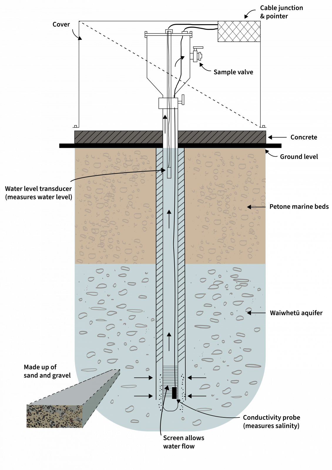
This is a simplified diagram of the underground conditions. For more detailed informaiton on the various layers please have a look at the Site Subsoil Classification of Lower Hutt.
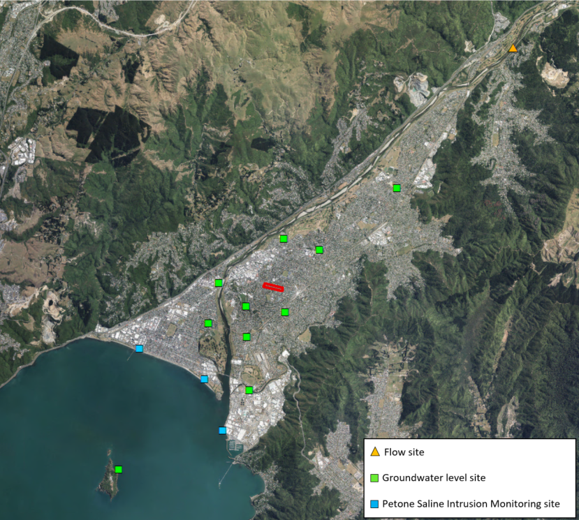
Petone Saline Intrusion Monitoring Network
Greater Wellington and Wellington Water monitor the Waiwhetu Aquifer at three locations on the Petone foreshore; Port Road in Seaview, McEwan Park, and near the Petone wharf (‘Tamatoa’). There is more than one monitoring bore at each of these sites because we monitor different depths in the aquifer. This is because saltwater is denser than freshwater, and may enter the aquifer near to its base.
We also have a network of monitoring bores throughout the Hutt Valley, and one at Matiu-Somes Island, to monitor various points in the Waihwetū aquifer. The data collected from monitoring bores is automatically collected and transmitted to us, and Wellington Water every 15 minutes.
View the data from our monitoring network.
We measure:
- Water Flow in the Hutt River to calculate how much water is escaping to recharge the groundwater.
- Electrical conductivity which tells us how much salt is in the water. Because the aquifer is connected to the sea, saltwater can enter if the groundwater pressure gets too low, affecting the water quality.
- Water level which changes with the tide, and informs how much water can be sourced from the aquifer.
Automatic alarms will be triggered if the level drops too low, or if electrical conductivity measurements get too high. Wellington Water must then reduce the amount of water that is being pumped at Knights Road to maintain the optimal levels.
Wellington Water
Wellington Water pump water out of the Waiwhetū Aquifer from eight bores located along Knights Road. There are also a small number of private users throughout the valley. The water for public supply is treated at Wellington Water’s Waterloo water treatment plant, and is then pumped to reservoirs around Hutt Valley and Wellington. Find out more about Wellington Water.
Get in touch
- Phone:
- 0800 496 734
- Email:
- info@gw.govt.nz