Clever buoy measures ocean health on the Kāpiti Coast
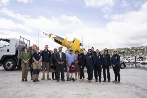
Gathering for the blessing of WRIBO-K with a karakia from Ngāti Toa Rangatira before the buoy is deployed.
A high-tech coastal buoy has been installed on the border of the Kāpiti Marine Reserve to monitor the impact of land activity on marine life - supporting conservation programmes with easily accessible data.
This new monitoring tool, known as WRIBO-K, is a joint venture between Greater Wellington Regional Council, NIWA and the Department of Conservation, and is also supported through Air New Zealand's backing of the Marine Sentinel Sites Programme.
Greater Wellington senior coastal scientist, Dr Megan Melidonis says, "This buoy provides real-time information which will help us to understand how land activities are impacting the marine environment.
"It measures sediment levels which increase during heavy rainfall due to erosion intensified by urban development, overgrazing, and riparian clearing. This sediment enters estuaries and coastal environments and smothers marine life."
This yellow buoy is a key component to the Greater Wellington Coastal Monitoring Programme which focuses on the causes of environmental impacts and identifies the success of ongoing restorative projects.
Department of Conservation technical advisor, Laura Wakelin says, "We're interested in capturing data on the Kāpiti Coast as this area undergoes rapid urbanisation. It will also alert us to changes in water quality which may have a knock-on effect on marine species living within the boundaries of the Kāpiti Marine Reserve."
NIWA physical oceanographer, Dr Joe O'Callaghan says, "With the О̄taki, Manawatu and Waikanae rivers converging on the Kāpiti Coast, the site chosen for this new buoy is great for understanding the concept of ki uta ki tai - which explores the interconnectedness between ecosystems."
WRIBO-K complements another buoy, WRIBO, moored in Wellington Harbour south of Matiu/Somes Island to establish a wider picture of marine health. Both yellow buoys measure currents, wind, salinity, dissolved oxygen, chlorophyll, water temperature, and suspended sediment, all of which are important in understanding how river, sea and land interact.
Opportunities to collect data for conservation don't stop there, with satellites overhead monitoring the sea surface for changes while the buoy takes measurements within the water. These two data sources will be compared, opening the gates to future remote monitoring that is less resource-intensive than physical monitoring.
The data from these buoys is available free on Greater Wellington's data-sharing website to help assist the development of conservation projects and to keep the community, iwi, divers, fishers and tourism operators informed on the environment's health.
Greater Wellington councillor Penny Gaylor is pleased to see WRIBO-K opening up opportunities for locals to use the latest scientific findings to support their hard mahi.
"It's great that our expertise and research can help the incredible amount of work happening in the community to restore and protect our water and the life that lives under its surface."
Kāpiti Coast Buoy Observations: Analysis of Physical and Water Quality Measurements
In 2018, a joint project between DOC, GW and NIWA was established to monitor the impact of land activity on coastal water quality. A telemetered coastal buoy, known as Wellington… Read more here
date_range Published 01 Aug 2022
Download now (PDF 3.9 MB) get_appGet in touch
- Phone:
- 0800 496 734
- Email:
- info@gw.govt.nz