-
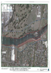
Appendix M: Regional Objectives and Policies
This document outlines the regional objectives and policies relating to consent application WGN130264.
alarm Published 06 Apr 2013 -
Appendix C: Land Ownership/Title Schedule
This document contains all the title schedule regarding the land ownership of places within the consent application.
alarm Published 05 Apr 2013 -
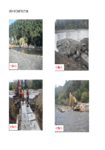
Appendix G: Activity Photographs
This document contains the photography regarding the activities within the consent application.
alarm Published 04 Apr 2013 -
Appendix H: Works and Maintenance Records
This document contains GWRC's works and maintenance records.
alarm Published 04 Apr 2013 -

Consent Application Forms
This document contains the original consent application forms.
alarm Published 03 Apr 2013 -
-
Farm Dairy Effluent Design Code of Practice
This document guides designers through the process of developing a farm dairy effluent (FDE) system, from the initial site investigation through to commissioning the final system. This document should be…
alarm Published 01 Apr 2013 -
Farm Dairy Effluent Design Standards
This document provides a set of standards which to assess the design of individual farm dairy effluent (FDE) systems in New Zealand.
alarm Published 01 Apr 2013 -