Waikanae River
http://www.gw.govt.nz/waikanaeriver
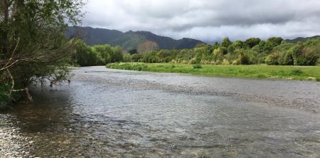
The Waikanae River flows from the western foothills of the Tararua Ranges about 50 kilometres north of Wellington.
Waikanae River Floodplain Management Plan
Waikanae River environmental management
The upper catchment covers 125 square kilometres of predominately regenerating native bush, mature forest and pasture.
The Waikanae River meanders through a diverse landscape which has changed significantly over the years. On the upper plain near the ranges, the river's course cuts through alluvial gravels deposited by the river, before moving down through coastal sand dunes between Waikanae and Paraparaumu, to the sea.
The Waikanae River is one of the distinctive natural features of the area and is highly valued by the local community. However, as well as being a great asset, there are times when the river floods, causing considerable damage and cost to the community. A major flood in the Waikanae River could cause millions of dollars worth of damage to property and community assets.
To find flood hazard information about a specific area, please view our GIS maps online: GWRC GIS flood Hazard Areas or KCDC GIS flood extents.
Waikanae Floodplain Management Plan, which is the result of work done by the Waikanae River Communities, Ati Awa ki Whakatongotai, Regional Council, and the Kāpiti Coast District Council, provides a blueprint for managing the river and the floodplain over the next 40 years. It is a living document, which means it will be changed and further developed over time.
We at the Regional Council are responsible for managing flood risks associated with the Waikanae River. The Waikanae Floodplain Management Plan sets out what we will do manage this flood risk. Our role in managing the river involves removing gravel, prevent erosion, repair and maintain stopbanks to reduce the risk of flooding.
You can download a copy of the plan, by clicking: Waikanae River Floodplain Management Plan.
Waikanae River Environmental Strategy, an outcome of the Waikanae Floodplain Management Plan, identifies key features of the river environment with a focus on the river corridor downstream of the Water Treatment Plant. The document is the combined effort of the Regional Council and Kāpiti Coast District Council with valuable contributions from the Department of Conservation, Ati Awa ki Whakatongotai and members of the community.
There has been significant environmental improvements in respect of restoration planting, development and enhancement of access and pathways for walking, cycling and horse riding. Many of these improvements are recommendations from an earlier version of the strategy, which have been implemented by us with Kāpiti Coast District Council and the community. You can download a copy of the plan, by clicking: Waikanae River Environmental Strategy.
Our operation and maintenance activities in Waikanae River are carried out under consent. Here is the land use consent link: Resource Consent.
This consent has been extended until a new consent is granted.
Please visit Kāpiti Coast District Council’s Local Restoration Groups webpage.
The Friends of the Waikanae River set up a nursery where they grow eco-sourced native plants for each planting season in winter. The group holds regular working bees. Find out more.
Contact: Russell Bell at russelljamesbell@gmail.com
Te Ati Awa ki Whakarongotai are the mana whenua iwi for the Waikanae River, and engage with GWRC on matters relating to river management and environmental enhancement. Find out more.
Our Flood Protection Department holds an annual public walkover along the banks of the Waikanae River, where flood protection projects, operational activities and environmental enhancements are discussed. To register your interest in attending, please email info@gw.govt.nz or phone 0800 4WN REG (0800 496 734).