A brief summary of climate and hydrological conditions in the region.
This service is regularly updated during periods in which closer monitoring is required (regardless of time of the year), in recognition that there is potential for dry spells, or irregular hydrological recharging. It does not define an official council position on drought or drought declaration. Outside of dry periods, less frequent updates synchronise with our latest seasonal outlooks.
Updated 19 March 2025
Next update due when there is a significant change of conditions or a new seasonal outlook.
Background
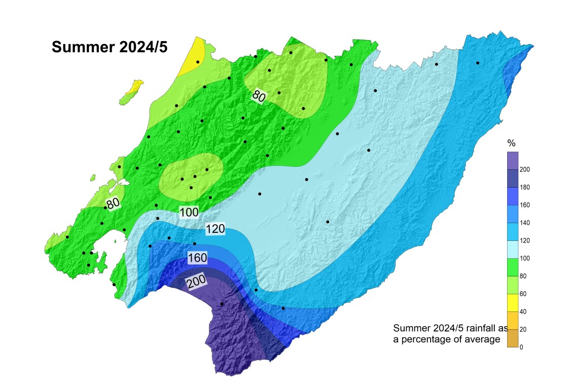
The new year brought well above average rainfall for the Wairarapa. While February was extremely dry for the entire region, for the total seasonal accumulation we had a positive water balance east of the main ranges. It was drier than normal towards the Kāpiti, Hutt Valley and Wellington as shown below. A weak La Niña presented little opportunity for ‘coupling’ between the ocean and the atmosphere. As a result, the main summer flow presented intermittent easterlies or south-easterlies diverging from a traditional La Niña. The oceanic water temperatures have been well above average over the Tasman Sea, but much cooler immediately east of New Zealand due to strong southerly bursts that have largely disrupted the normal summer flow.
Current situation
Soil moisture levels have been below average west of the main ranges and back near normal for the most part in the Wairarapa, after an extremely dry February. The national drought index is showing most of the region classed as dry, especially west of the Tararua ranges where the lack of rain has been much more persistent. A couple of fronts in March have brought some welcome relief, improving river flows and soil moisture. While some smaller Ruamāhanga rivers and valley floor streams are back under water take restrictions after a couple of weeks of respite, most of the larger rivers have not yet receded back into restriction territory.
Meteorological outlook
International climate models are predicting that the atmosphere will continue to be influenced by an intermittent La Niña flow during autumn, before returning to a neutral ENSO state. This implies that we will likely continue to experience occasional fronts with some degree of ongoing recharging. Additional easterly rainfall events should prevent an aggravation of the normal seasonal dryness in the Wairarapa, going forward from the autumn equinox. Despite these favourable indicators from the main climate drivers, a continuing close monitoring is recommended.
Climate change
The ‘normal’ longer-term water balance is becoming increasingly hard to maintain quite possibly due to climate change influences, and increased high frequency climate variability, with more unreliable weather patterns. Droughts are expected to become more severe and frequent in the Wellington region, particularly in the Wairarapa. Even if international climate policy efforts were to successfully contain global warming under 1.5-2 degrees (the Paris Agreement’s ambition), it is important that we enhance our water resilience and be prepared for more unreliable climate patterns with both extreme dry and extreme wet periods. We note that the warming of the land also means that evapotranspiration will greatly increase, so the soil will likely need more ongoing rain to maintain ideal moisture levels, compared to what it has needed in the past.
View the latest national drought index state
View the national drought forecasting dashboard
View the latest seasonal report:
Climate drivers and seasonal outlook for the Wellington Region - Summer 2024-25 summary Autumn 2025 outlook
date_range Published 31 Mar 2025
Download now (PDF 1.7 MB) get_appBrowse the data
Anomaly Maps
How different has recent rainfall/soil moisture been compared with the same time in previous years?
Site-specific graphs
| Area | Rainfall | Soil Moisture |
| Kapiti Coast (lowland) | Otaki at Depot | |
| Kapiti Coast (high altitude) | Penn Creek at McIntosh | |
| Porirua | Horokiri Stream at Battle Hill | |
| Wellington City | Kaiwharawhara Stream at Karori Reservoir | |
| Hutt Valley (upper catchment) | Hutt River at Kaitoke Headworks | |
| Upper Hutt | Upper Hutt at Savage Park | Upper Hutt at Savage Park AQ |
| Wainuiomata | Wanuiomata River at Wainui Reservoir | |
| Wairarapa (high altitude) | Waingawa River at Angle Knob | |
| Wairarapa Valley (north) | Kopuaranga River at Mauriceville | |
| Wairarapa Valley (Masterton) | Ruamahanga River at Wairarapa College | Wairarapa College AQ |
| Wairarapa Valley (south) | Tauherenikau River at Racecourse | Tauherenikau River at Racecourse |
| Wairarapa (north-eastern hills) | Whareama River at Tanawa Hut | Whareama River at Tanawa Hut |
| Wairarapa (south-eastern hills) | Waikoukou at Longbush | Waikoukou at Longbush |
Get in touch
- Phone:
- 0800496734
- Email:
- info@gw.govt.nz